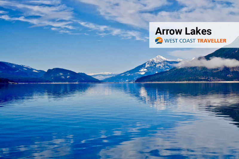
There are several communities along the shores of Upper & Lower Arrow Lakes: Nakusp, Arrow Park, Burton, Edgewood, Fauquier and Trout Lake.
These communities were started by settlers who relied on the waterways as their main travel routes, aboard stern-wheelers that sailed up and down the lakes carrying passengers &andcargo.
The largest of these communities is Nakusp, which prides itself on its waterfront walkway overlooking Upper Arrow Lake, its beaches and the nearby Halcyon natural hot springs.
Burton is on the beautiful alluvial fan formed by Caribou Creek and well-known for its excellent agriculture and timber values.
Fauquier is also a farming community but also boasts a popular lakeside golf course.
The community of Trout Lake is located on the shores of a lake of the same name and is rich in mining history, with access to amazing backcountry recreation.
The Sinixt First Nation lived along the Arrow Lakes for thousands of years, using the waterways as their transportation routes, as did the first European explorers. Fur trading, mining, agriculture and logging are the main economic activities.
The Selkirk Mountains, on the east side of the Arrow Lakes, and the Monashee Range on the west, hold many smaller lakes, accessible by backcountry roads. Many mountain peaks and ridges offer astounding views of the lakes and valley vistas below.
Facts
• Blanket Creek, Arrow Lakes, McDonald Creek and Syringa are all provincial parks in the area.
• The Upper Arrow Lakes Ferry service operates across Upper Arrow Lake from Galena Bay on the eastern shore of the lake to Shelter Bay on the western shore of Upper Arrow Lake. This free ferry service connects Highway 23 that runs from Revelstoke to Nakusp in the Kootenays.
• The Needles Cable Ferry service operates across Lower Arrow Lake from Needles on the western shore to Fauquier on the eastern shore of Lower Arrow Lake. This free ferry service connects Highway 6 that runs from Castlegar in the Kootenays to Vernon in the North Okanagan.
• The BC Rockies region is a motherlode of serious adventure, with the mountainous parks presenting some truly extraordinary landscapes to explore. The Columbia Valley is surrounded by the Rocky Mountains on the east and the Bugaboos on the west, with the Columbia River rolling through the southern part of the valley.
• Ongoing summer events include the ArtWalk and farmers’ markets in Nakusp, Burton and Edgewood, and Music in the Park in Nakusp. During winter, enjoy snowmobile poker runs, fishing derbies or races at the Summit Lake Ski Hill and Tube Park. You’ll also find lots of cultural events hosted by the Arrow Lakes Arts Council.
In the Arrow Lakes region, summers are short, warm and partly cloudy, and winters are typically cold and mostly cloudy.
Destination BC is developing a new campaign to promote hyper-local travel where residents are “tourists-in-their own hometown,” while practising the COVID-19 safety protocols as recommended by the B.C. Provincial Health Officer. Many B.C. parks are now open, and national parks were to open as of June 1.
(Check this website for current details on travel.)
Getting Here
Driving: Travel time from Vancouver to Arrow Lakes takes just over seven hours via BC-6. The distance is 597.2 km (230 mi).
Dream now, travel later. To plan for future adventures here and throughout the West Coast, visit westcoasttraveller.com

 Summerland: These ornamental gardens will delight you, and so will the admission fee