By Christopher Reynolds, Los Angeles Times
Bring water. Stop to sniff the creosote bushes. Keep an eye out for oases.
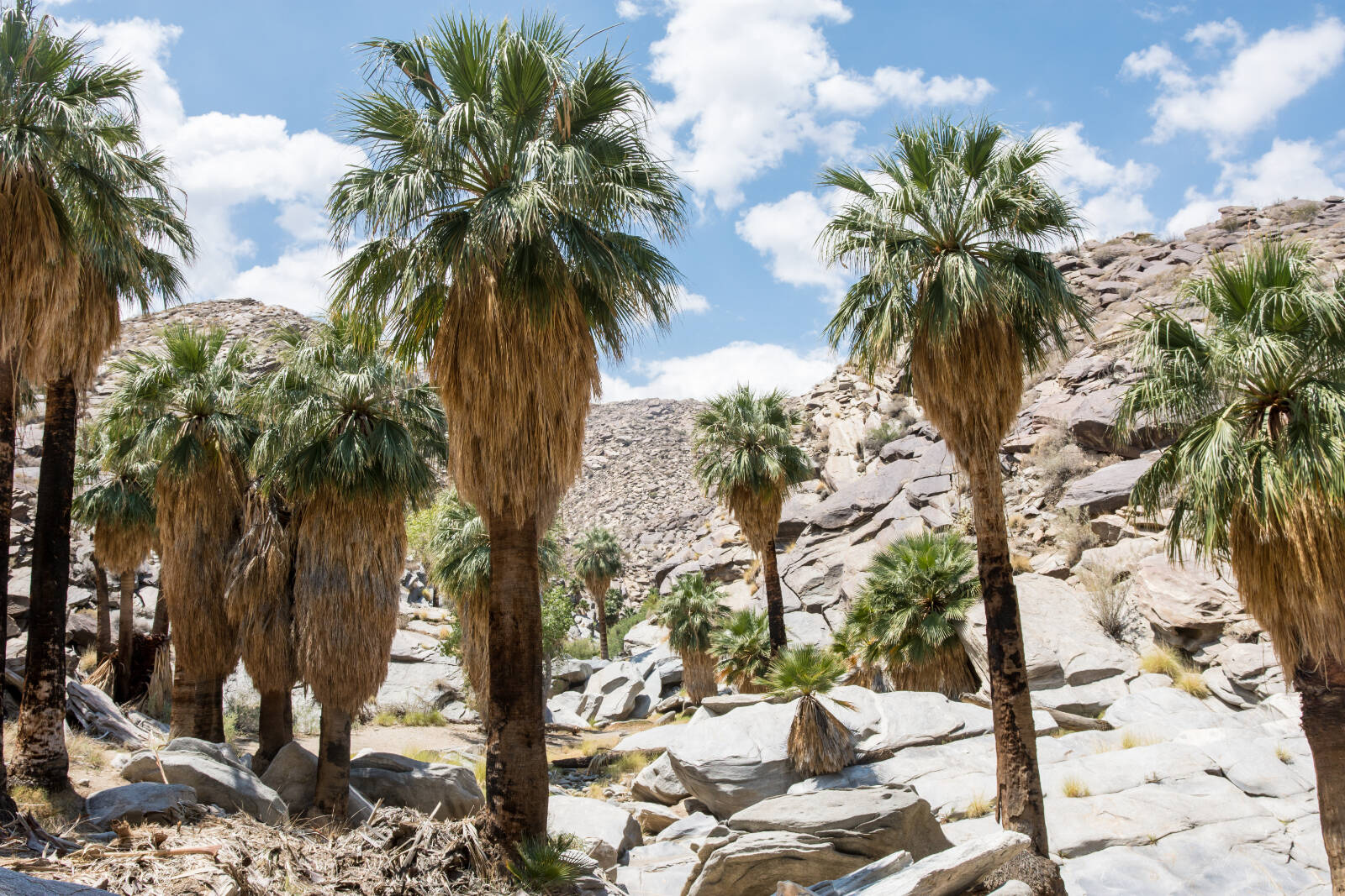
This is good advice on many desert trails, and it’s doubly true on the outskirts of Palm Springs, where the Agua Caliente Band of Cahuilla Indians owns several publicly accessible canyons. In Palm Canyon, you find the world’s largest California fan palm oasis. In Andreas Canyon, there’s a year-round creek. In Tahquitz Canyon, if the weather has been wet enough, you’ll reach a 60-foot waterfall and a pool where Jim Morrison once waded.
But the biggest surprise for a newcomer might be the backstory: On this territory, the tiny Agua Caliente tribe has come back from near death and built a business empire worth billions. Now the tribe, whose members are the most powerful property owners in Palm Springs, is getting ready to share its culture, including some painful history, with more visitors.
You can hear parts of that story on a hike with a ranger, as I did recently in Tahquitz Canyon, or hike on your own in Tahquitz, Palm, Andreas or Murray canyons (details below).
Before 2023 is done, you may also be able to soak up more history at the tribe’s long-awaited cultural plaza, which will include a museum next to a spa built around the waters that gave Palm Springs its name.
Either way, the canyons are a good start.
READ MORE: The writer who’s been everywhere shares his 2023 California travel wish list
“Some of my best memories are hiking Tahquitz Canyon,” Agua Caliente Tribal Chairman Reid D. Milanovich, 39, said in a recent interview. “I have a lot of pictures of myself and my little sister and cousins going up with my parents or other tribal members.”
When he takes newcomers there, “I really try to emphasize the importance of being observant and just listening. Listening to the plants blowing in the wind, listening to the birds chirping, listening to what those canyons are telling you. That experience is really hard to put into words.”
A hike into history at Tahquitz Canyon
A few minutes before 10 a.m. on a mild winter day, Agua Caliente Tribal Ranger Christopher Castro joined me and a family group hiking the canyon from Tahquitz Canyon Visitor Center to Tahquitz Falls and back, a 1.8-mile round trip.
“The area we’re standing in is an old village site,” Castro said, looking up to the 200-foot canyon walls on one side, down to the trickling seasonal creek on the other. The name Tahquitz comes from a shaman who, according to myth, turned against the Cahuilla people and was exiled to the canyon.
Though Castro isn’t one of the tribe’s roughly 500 members (none of the Tahquitz rangers is), he has been doing the job for a decade, and he sketched an evocative picture of life before nonnatives appeared.
READ MORE: Hiking SoCal’s mountains: How to hike safely when snow and ice make trails dicey
We paused at a standing rock with red re-creations of ancient markings. A few steps away, Castro pointed out a boulder with a hole in the middle, where long-ago meals of mesquite beans were prepared by tribal members with mortar and pestle.
At a creosote bush — a -tu-kul in the Cahuilla language — Castro explained how families would boil the leaves to make tea, often sweetened with honey.
The Agua Caliente tribe, one of several with deep roots in the Coachella Valley, has lived among the canyons and springs for thousands of years, including during the hard times that began when European immigrants arrived and started grabbing land in the 19th century.
The tribe’s reservation, its boundaries drawn by U.S. officials in the 1870s, includes more than 31,500 acres in Palm Springs, Cathedral City, Rancho Mirage and unincorporated Riverside County, much of it laid out like a vast checkerboard, alternating between land owned by the tribe and land that isn’t.
Why a checkerboard? Because federal officials had given the other pieces of the checkerboard to the South Pacific Coast Railroad, which they hoped would build a rail connection between California and Arizona.
When that didn’t happen, the railroad sold its holdings to developers who eventually created a winter resort area.
By the late 1930s, some show business people had begun to visit and Palm Springs had incorporated as a city.
READ MORE: Why you won’t need reservations to visit Yosemite National Park next year
This gave the tribe a strange set of resources: a bath house at the mineral springs downtown; several canyons with water; and dozens of checkerboard squares of real estate (1 mile by 1 mile) in an increasingly urban area, some owned collectively, some individually.
But the tribe was tiny, and elders were dying off. By 1917, writes Lowell John Bean in his history of the Agua Caliente, From Time Immemorial, the reservation’s population was down to 51. In the early 1950s, believing that tribal culture had dwindled so dramatically that they’d reached the end of the line, elders burned their ceremonial house and religious artifacts.
But it was far from the end. By 1959, the tribe’s first all-female council had persuaded the U.S. Congress to approve long-term leasing of reservation land. That meant tribal members could make the same sort of lucrative development deals being made elsewhere in town. Suddenly, the tribe had a new economic trajectory.
“We think of history as 100 years ago, 200 years ago. This was not that long ago,” said Milanovich.
Another big win came in the 1990s, when tribes across the U.S. won court decisions allowing casinos on reservations.
The Agua Caliente opened its first casino under a tent in Palm Springs. Then came a bigger casino in Rancho Mirage in 2001. Then a third in Cathedral City in 2020. The Rancho Mirage resort, which is the fanciest, has added a 340-room hotel (where weekend rates typically start north of $400), the Sunstone Spa and a performance venue, the Show.
How wealthy is the tribe? Of more than 60 California tribes with casinos, only the Agua Caliente has three. Riverside County employment figures suggest the tribe has at least eight times as many employees as it does enrolled members. (Milanovich would say only that the tribe is self-sufficient, with housing, health and educational programs in place.)
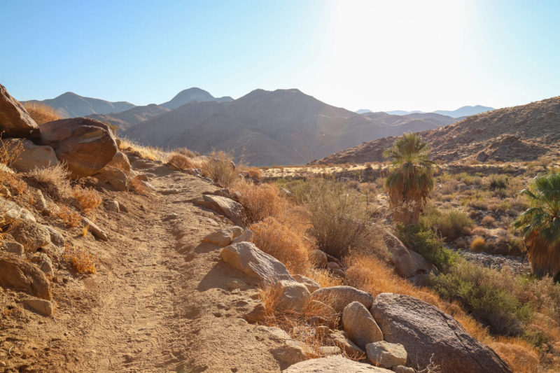
As we made our way up the canyon, Castro showed us brittlebush, whose sap “was used to alleviate toothaches,” and desert lavender. Along the creek, sycamores outnumbered palms, their brown and orange leaves throwing welcome shadows.
In summer, Castro said, “I’ve measured temperatures as high as 183 degrees” on the ground.
READ MORE: What’s happening in Joshua Tree is a ‘dream’ — and possibly a curse
Climbing gradually, the trail gained about 350 feet. Then we rounded a corner and there was Tahquitz Falls, 60 feet tall and burbling between boulders into a deep, dark pool.
“Woooowwwww,” said Geyorg Baker, age 9, who was hiking with his father, Brenden Baker and grandfather John Hermansen, all from Lompoc.
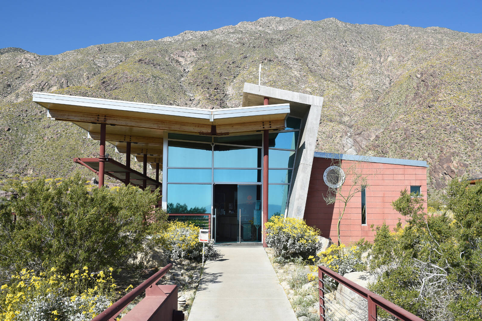
Foot traffic on the Tahquitz Canyon Trail, Castro said, has almost tripled since the pandemic, approaching 1,000 people some days. The tribe has expanded parking and hired more rangers to staff the sleek, neo-Modernist visitor centre (designed by Lance O’Donnell in 1999) where hikers check in.
The canyon actually goes back seven miles, Castro told us, but only the first mile (to the falls) is open to visitors. This is not surprising, given its 20th century history.
The canyon was a popular hiking area for years. In fact, the falls can be seen in the 1937 Frank Capra film Lost Horizon, and tourists paid to ride burros up to the falls in the late 1940s and early ’50s. But when the ’60s arrived and hippies started showing up, tribal leaders noticed a surge in vandalism and litter.
“This used to be a party canyon,” Castro said. “You’d have thousands of kids here during spring break. … There are actually photographs of Jim Morrison at the waterfall.”
The troubles reached a climax in April 1969, when legions of partyers and college students on spring break converged on the desert for the two-day Palm Springs Pop Festival (whose acts included Canned Heat and the Flying Burrito Brothers). The crowds invaded the canyon, leaving heaps of litter and waste.
After that, the tribe tried to close the canyon to outsiders for 30 years. But its location near the city made it a target for partyers, people who wanted to hide and those who had no place else to go.
So in the late 1990s, with the tribe’s wealth growing, leaders resolved to clean out the canyon and evict squatters from their caves among the canyon’s tumbled granite boulders.
Once that was done, in 2001, the tribe reopened the canyon to the public — first for escorted hikers only, later for hikers on their own, so long as they paid admission and followed the rules. (As in many parks, pets, fires, smoking, alcohol, bikes, drones, firearms, fireworks, loud music and lingering after dark are forbidden.)
Like most ranger-led hikes, ours concluded with a stop at Lookout Rock — Kak wa wit in the Cahuilla language — where we could step up and scan the desert.
“Cleaning up Tahquitz is a way to say, ‘Yes, this is ours’ and instill a sense of pride,” then-Tribal Chairman Richard M. Milanovich, Reid Milanovich’s father, told Times staff writer Diana Marcum in 1998. “It’s not possible in today’s world to keep this special place for ourselves. … We made a unanimous decision to open the canyon so everyone can better understand how our ancestors lived.”
A generation later, the younger Milanovich says, the tribe’s soon-to-open cultural plaza at Tahquitz Canyon Way and Indian Canyon Drive is an extension of the same effort.
Unveiling a new cultural plaza: ‘A dream of my tribe for decades’
Sometime in 2023, the tribe is due to open the Agua Caliente Cultural Plaza on the 5.8-acre site of the mineral spring that has always been a centerpiece of tribal culture. (The site previously held the tribe’s Spa Hotel, which stood from 1963 to 2014, when it was razed.)
“Those hot springs waters are the heart and soul of this tribe,” Milanovich said. “They aren’t just myths or legends of the healing power of this water. That stuff is real.”
The new complex’s Spa at Séc-he will operate as a commercial spa, with two outdoor pools, 22 private mineral soaking tubs, two salt caves, two “zero sensory float pods” and a cryotherapy unit.
Next door will stand a museum, arranged in a circular floor plan to echo the shape of a basket. Though the Agua Caliente has had a museum since 1991, this takes the enterprise to another level, from about 1,600 square feet to about 48,000.
The museum’s executive director is Steven Karr, who led the National Cowboy & Western Heritage Museum in Oklahoma City from 2014 to 2017 and spent 2001 to 2011 as a curator at the Natural History Museum of L.A. County and the Autry Museum of the American West.
“How do you squeeze thousands and thousands of years into a 48,000-square-foot building?” Milanovich asked. “That’s almost impossible.” The cultural plaza, he said, is “one of the most important projects this tribe will ever produce.”
In recent years, many California tribes have been stepping into cultural tourism. The Yurok in northernmost California has begun offering guided trips on traditional redwood canoes along the Klamath River. In Lakeside, San Diego County, the Barona Cultural Center & Museum includes a native seed library and artifacts from the Kumeyaay/Diegueño culture. In Santa Barbara County, the Santa Ynez Chumash Museum and Cultural Center is due to open this year. The Agua Caliente museum is among the biggest investments of this kind so far.
“A museum of this caliber has been a dream of my tribe for decades,” Milanovich said. He called it “a project that clearly defines who we are as a people, told through our own voice.”
If you go: Hiking the canyons of Palm Springs
The Agua Caliente tribe manages Palm, Andreas and Murray canyons as one unit known as Indian Canyons, Tahquitz Canyon as another. All are part of Santa Rosa and San Jacinto Mountains National Monument, jointly run by the tribe, the U.S. Forest Service and the Bureau of Land Management.
- Palm Canyon, home to hundreds of native California fan palm trees, has a parking lot and a trading post at its trailhead. It’s 15 miles long, and the most popular hiking route is the mile-long Palm Canyon Trail, which runs along the canyon floor among the palms. If you combine that trail with the Victor Trail, you descend, then rise from the canyon floor to a ridge as you double back to the Palm Canyon store and parking lot. That hike is 2.7 miles and classified by rangers as moderate.
- Andreas Canyon’s main attraction is Andreas Creek, which runs year-round between rock walls, watering many California fan palms, sycamores, cottonwoods, willows and about 150 other plant species. The Andreas Canyon Trail goes about half a mile up the canyon, crosses the creek, then returns to the canyon parking area. In all it’s an easy 1.2 miles. The canyon was closed in the wake of winter storms; check in advance before setting off to hike there.
- Murray Canyon is just south of Andreas Canyon and shares the same parking area. It gets less foot traffic than the other canyons but includes hiking and equestrian trails and the Seven Sisters waterfall. Like the others, it is a habitat for the endangered Peninsular desert bighorn sheep. The Murray Canyon Trail is 4.7 miles and rated moderate.
Indian Canyons visitors pay $12 per adult, $7 per student or senior, $6 per child ages 6 to 12. Tollgate location: 38520 S. Palm Canyon Drive, Palm Springs More info: 760-
- Tahquitz Canyon visitors pay $15 per person, $7 per child ages 6 to 12. The 1.8-mile round-trip hike includes 350 feet in elevation gain, much of it on stone steps 12 to 15 inches high that can be strenuous for some. Little shade, no water fountains, no restrooms. The trail is open daily (7:30 a.m. to 5 p.m.) Oct. 1 through July 4. Between July 5 and Sept. 30, the canyon is open only Fridays, Saturdays and Sundays. More info: 760-
323-6018; tahquitzcanyon.com.
Plan your adventures throughout the West Coast at westcoasttraveller.com and follow us on Facebook and Instagram @thewestcoasttraveller. And for the top West Coast Travel stories of the week delivered right to your inbox, sign up for our weekly Armchair Traveller newsletter!







 Report highlights fiscal burden of visitation on Banff, Canmore + Jasper